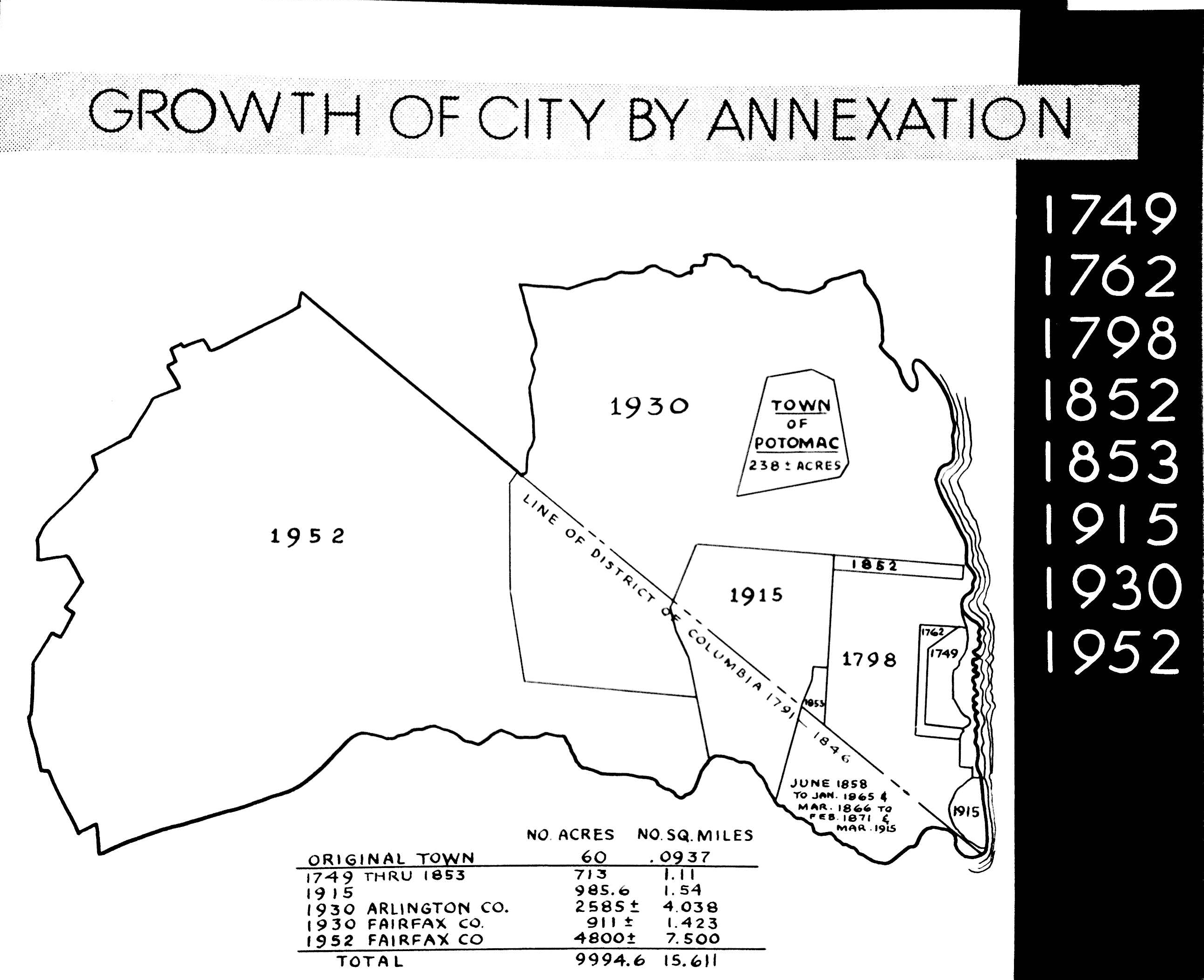
When the city started, it was a couple blocks along the waterfront of 700 acres. Two hundred years later, it would grow to nearly 10,000 acres. How did Alexandria gain this much land over time? It took it. Over its 200-year expansion, the story of Alexandria is one of steady growth pushing the city to annex more and more of its neighbors in every direction.
The original boundaries of the city were established in 1749 when a charter was issued to establish a town covering the lands on the south side of the Potomac River. The 84 lots that made up the town were 60 acres in total. Much of what we know as Old Town today came from this original parcel. Though it would later be incorporated into the District of Columbia for a few years, Alexandria was originally incorporated as a town in Virginia.
The first expansion was in 1762, which added another few blocks around that original boundary. By 1796, records at the time show that Alexandria was continuing to steadily grow and had undergone another westward expansion. That year, Alexandria was also incorporated into the District of Columbia. This lasted until 1846, when Alexandria became part of Alexandria County Va., then was chartered as a city in 1852. Throughout the 1850s, the city continue to swallow small parcels south and west of the city limits, including parts the Hooff’s Run and Hunting Creek areas of Fairfax. In 1865, the city tried to withdraw jurisdiction from these swampy parcels that had been added as part of the 1858 charter but by 1871, the dividing line between Fairfax County and Alexandria was established as Hooff’s Run to the west and where it runs into the Potomac in the south, today known as Cameron Run and still the boundary between Fairfax and Alexandria.
These boundaries stayed fairly consistent until 1915, when Alexandria annexed 866 acres from Alexandria County and 450 acres from Fairfax County. This was mostly a northwest expansion of Old Town, but also included the acquisition of Jones Point. Then in 1930, the city nearly doubled in size when it annexed large portions of Arlington County to the north, bringing the city boundaries from Cameron Run in the south to Four Mile Run in the north. According to court records from the time, the land was given to Alexandria for use in the city’s future development and because the city was in a position to improve the land. This brought Del Ray, Potomac, and Potomac Yards into Alexandria.
The final major expansion occurred in 1951: when Alexandria took the West End. After the 1930 acquisition, the westernly dividing line was Quaker Lane, but the city had its sights on the growing developments further west. The Virginia Supreme Court of Appeals upheld Alexandria’s decision to annex what was part of Fairfax, and the city more than doubled as a result; bringing in 7.25 square miles and adding 11,000 new residents to the city.
“The historic City of Alexandria lies in the most thriving and rapidly growing urban community in Virginia,” read the annexation ordinance. “The City’s proximity to the Nation’s Capitol is believed to assure the pernancy of this phenomenal growth … The tripling of its population in 20 years [since the last expansion] has resulted in a density that is far too great. The corporate line is extremely and unduly contracted. The City for all practical purposes is completely built up. Sufficient land desireable for residential and business expansion is not available to accommodate the needs and desires of the CIty’s present population or of the new population of which the City of Alexandria is the center. If the City is to grow it is imperative that its corporate line be extended.”